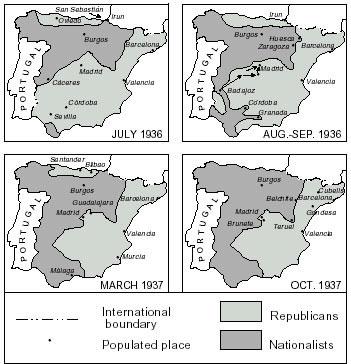
These maps show the changes in republican- and nationalist-held areas during the first half of the Spanish Civil War.
In November 1936 the 3000 members of the International Column and their Spanish comrades halted the nationalist advance on Madrid. The Spanish capital withstood continual bombing and artillery bombardment until it eventually fell in March 1939.
During 1937 Franco’s nationalist forces were boosted by the arrival of Italian troops and Spanish colonial soldiers from Morocco, and later by the arrival of the German Condor Legion, equipped with Heinkel He 51 aircraft. The Condor Legion was responsible for the bombing of civilians at Guernica in the Basque country, an atrocity depicted by the Spanish artist Pablo Picasso.
The nationalist forces seized Malaga, Guernica and Bilbao by mid-1937, but were unable to capture Madrid. The cities of Santander and Gijón soon fell and the republican army in the Basque region surrendered, effectively ending republican resistance in the north. By the end of November 1937 Franco's troops were closing in on the republican capital, Valencia, forcing the government to move to Barcelona.
The republicans enjoyed a morale-boosting victory in January 1938 when they captured the city of Teruel from the nationalists. But this success was short-lived. Thanks to German and Italian air support the nationalists recaptured Teruel within a month.
In early March 1938 the nationalists launched an offensive that swept to the Mediterranean, cutting the republican-held portion of Spain in two. In May the government attempted to negotiate a peace settlement but a supremely confident Franco demanded its unconditional surrender.
The fighting intensified as the nationalists advanced on Valencia. In late July 1938 the republicans launched a full-scale offensive in a bid to reconnect their territories. The four-month Battle of the Ebro failed to reunite republican territory. Nearly 40,000 lives were lost – 30,000 on the republican side. This fighting took place against the backdrop of the Franco-British appeasement of Hitler at Munich. The Munich Agreement, which effectively handed Germany Czechoslovakia on a plate, was soul-destroying for the republicans, who now realised that Britain and France were not going to come to the rescue.
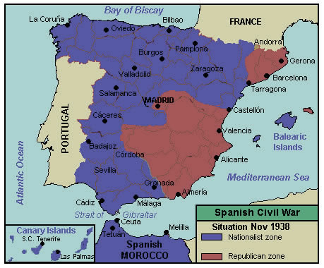
The situation in November 1938.
The defeat at Ebro was the beginning of the end. Franco now prepared to invade Catalonia and the city of Barcelona. The principal Catalan cities were captured by early February 1939. Two weeks later Britain and France recognised the Franco regime.
Madrid and Valencia remained as the key republican strongholds thwarting Franco. Madrid fell on 28 March and Valencia surrendered next day. Franco proclaimed victory in a radio speech on 1 April 1939, when the last republican forces surrendered
The map images on this page are from Wikimedia Commons