Map showing movements of the Burgess gang

Map showing movements of the Burgess gang

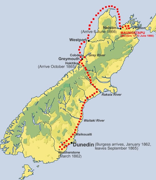
Map showing main locations mentioned in the text. Richard Burgess and Thomas Kelly (then known as Noon) took three weeks to get from Dunedin to Hokitika. They were escorted by the Otago police to the provincial border with Canterbury, the Waitaki River. They then evaded Canterbury police as they travelled on to Hokitika via the Rakaia Gorge and the Arahura Valley.

Over the next few months the gang committed a series of crimes on the West Coast, including the murder of George Dobson, who had helped explore suitable routes from Canterbury to the West Coast – Arthur's Pass is named after his brother. From Greymouth they travelled by steamer to Westport and then on to Nelson. Intending to walk to Picton, they got as far as the Wakamarina goldfields, where they hatched a plan to commit murder and robbery on the Maungatapu Track.

Community contributions

3 comments have been posted about Map showing movements of the Burgess gang

What do you know?

admin

Posted: 31 Aug 2009

Hi Marcus
Thanks for your comments. I think 'escorted' is ok in this context. The map date is correct - though I see it might look like a '6' at first glance.
We have fixed the text re-route taken over the Alps. The map will be updated shortly.
regards, Jamie Mackay, Web Editor.

Marcus Pedersen

Posted: 29 Aug 2009

I just noticed that your map, apart from showing incorrectly that they went via Arthurs Pass, says they left Dunedin September 1866, so obviously a typo.

Marcus Pedersen

Posted: 29 Aug 2009

I think followed or watched closely might be a better word than 'escorted' as it implies that they were officially removed from Otago. Richard Burgess terms it: "We were thus escorted, not openly, the delegated one either preceding us or not far away." (p86) Also, they went to the West Coast up the Rakaia crossing over to the Arahura, not Arthurs Pass. (p87) Source: Confessions of Richard Burgess, ed. David Burton, (Reed, 1983)