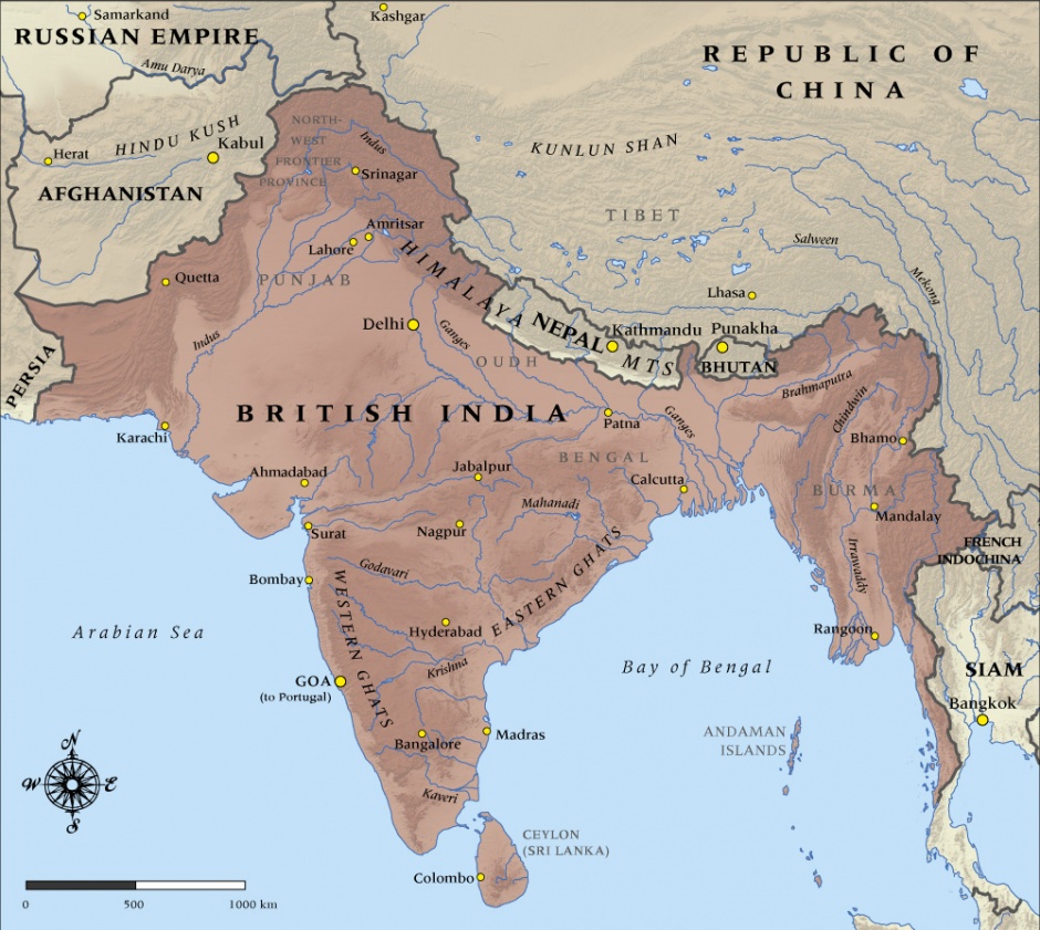
Map of British India in 1914

Map of British India in 1914

You can also download a hi-res copy as a pdf (6.9 mbs).

This map shows the boundaries and major cities of British India at the time it entered the First World War in 1914.

Community contributions

6 comments have been posted about Map of British India in 1914

What do you know?

P.V.Ravi Chandran

Posted: 23 Mar 2023

First depict the Cis-Kuen Lun Tract in Kashmir extending from Chhogori Peak K2 in central Kashmir to the Taghdumbash Pamir and Mariom Pamir and the Kukalang, Yangi, Kilian, Sanju-la and Hindu-tash Passes 36°40'02"N 78°22'44"E in northern Kashmir as part of India before expecting Indians to download your map!

Chris Abdul-Wahhab

Posted: 20 Mar 2022

Ceylon (Sri Lanka) was never part of British India. When coastal (Dutch) Ceylon was under British occupation (1793-1802) during the Napoleonic wars and their immediate aftermath, these regions were under the administrative jurisdiction of the British Presidency of Madras (India). However, it was still legally part of the Dutch Republic which had, de facto, been replaced by the French puppet state of the (Dutch) Batavian Republic. The French ceded sovereignty over Dutch Ceylon to Great Britain by the Treaty of Amiens of 1802. The Honourable Frederick North (later the 5th Earl of Guilford), the first British Governor of Ceylon and all his successors down to the last Governor, Sir Henry Monck-Mason Moore reported directly to Her Majesty's Principal Secretary for the Colonies rather than to either the Governor of the Presidency of Madras, the Court of Directors of the East India Company or (from 1858) the Governor-General of India or later, the Viceroy and Governor-General of India.

Your map, as of 1914, however omits to show certain territories of the Empire of India (British Raj). The Chief Commissioner's Province of Aden and the Trucial States (both in southern Arabia) were, until 1932, within the jurisdiction of the Viceroy and Governor-General of India.

In addition to Aden and the Trucial States, the Persian Gulf Residency also was under the jurisdiction of the Viceroy and Governor-General of India. The constituent states of the Residency were Princely States of the Empire of India (British Raj). The Persian Gulf Residency included today's Bushehr (now in Iran), the sheikdoms that now make up the United Arab Emirates, Kuwait, Bahrain, and Qatar. These territories were separated from India at Indian independence and remained British protected states until they were, essentially, forced to become independent because Great Britain could no longer afford to rule them. Bushehr was ceded to Iran.

Tom

Posted: 07 Jun 2017

This map shows China bordering British India ... But I believe Tibet was still an autonomous nation at that time, until after WWII and the invasion of Tibet by Chinese forces.

Krr

Posted: 16 Feb 2013

China didn't occupy NE part of Kashmir(Aksai Chin) till the 1962 Sino-Indian war.

admin

Posted: 23 Jan 2013

Hi Ben - I think we are correct here - see the China in WW1 page for more info: http://www.nzhistory.net.nz/war/republic-china-facts


Regards, Jamie Mackay

Ben Makin

Posted: 22 Jan 2013

Surely China was still an Empire in 1914, not a Republic>